|
|
MONTHLY UPDATE: SEPTEMBER 2018
Hi Infrastructure Universe,
Greetings from the Infrastructure Universe! Over the last few weeks, Autodesk has released a bunch of hotfixes and updates. Also, make sure you check out all the new videos and tools below!
If you know of anyone who could benefit from or enjoy being part of the Infrastructure Universe, don't forget to share this email with them ask them to join the mailing list!
|
|
|
|
|
Software Updates & Hotfixes
|
|
|
|
|
River and Flood Analysis Module 2018.1
Readme
|
|
|
|
The most recent update for the River and Flood Analysis Module 2018 included bug fixes, such as:
- Fixed an issue where Autodesk AutoCAD Civil 3D 2018 would become unresponsive for some users when attempting to use the Autodesk River and Flood Analysis Module 2018 commands due to the module being installed to an inaccessible location
- Fixed an issue where Autodesk AutoCAD Civil 3D 2018 would close unexpectedly when opening a drawing that contains Autodesk River and Flood Analysis Module objects if the Default Template File Name for QNEW option was set to some custom drawing templates
Read more about the updates. Use the Autodesk Desktop App to download and install this update.
|
|
|
|
|
|
River and Flood Analysis Module 2019
Readme
|
|
|
|
The most recent update for the River and Flood Analysis Module 2019 includes features such as:
- Ability to automate HEC-RAS cross-section cutting, water surface analysis, flood plain mapping, and all related modeling tasks
- Ability to utilize numerous automation mapping tools for extracting cross sections from various digital terrain sources including contours, TINs, DTMs, DEMs, LiDAR data, survey files, surveyed cross sections, etc.
- Ability to perform sophisticated bridge and culvert analysis as well as automating the process of designing and analyzing roadway crossings.
- Ability to automate mapping of bank station locations, channel and overland flow lengths, levee locations, ineffective flow areas, Manning’s roughness data from topographic map data.
- Ability to perform automated bridge scour computations for FHWA and state DOT roadway studies.
- Ability to automatically generate floodplain and floodway maps, ready for FEMA and other agency submittals
Read more about the updates. Use the Autodesk Desktop App to download and install this update.
|
|
|
|
|
|
Geotechnical Module for Civil 3D 2019
Readme
|
|
|
|
The most recent update for the Geotechnical Module 2019 includes features such as:
- Ability to import borehole data
- Ability to create 3D borehole modules
- Ability to display 2D borehole strip diagrams
- Ability to display 2D borehole diagrams on Autodesk Civil 3D profiles based on a buffered alignment
- Ability to create and manage Autodesk Civil 3D surfaces based on borehole data
Read more about the updates. Use the Autodesk Desktop App to download and install this update.
|
|
|
|
|
|
|
Autodesk Import-Export Extension for GENIO 2019
Readme
|
|
|
|
The most recent update for the Import-Export Module for GENIO 2019 includes features such as:
- Ability to import Bentley MXROAD alignments, profiles, surfaces, points and feature strings into Autodesk Civil 3D
- Ability to export Autodesk Civil 3D model elements including points, alignments, profiles, corridor feature lines, and grading feature lines intothe Bentley MXROAD format.
Read more about the updates. Use the Autodesk Desktop App to download and install this update.
|
|
|
|
|
|
Autodesk MicroDrainage Utility 2019
Readme
|
|
|
|
The most recent update for the MicroDrainage Utility 2019 includes features and changes such as:
- Utility to aid the renaming of the pipe network to naming convention
- Ability to export pipe network to MicroDrainage file formats
- Ability to import and update existing network from a MicroDrainage file (MDX/SWS/FWS)
- Improved export capabilities including ability to exclude “Null Structures”
Read more about the updates. Use the Autodesk Desktop App to download and install this update.
|
|
|
|
|
|
Autodesk Data Extension for 12d® 2019
Readme
|
|
|
|
The Autodesk Data Extension for 12d® 2019 for Civil 3D is a package of tools designed to work with common Australian and New Zealand Standards in a single download.
Read more about the updates. Use the Autodesk Desktop App to download and install this update.
|
|
|
|
|
|
InfraWorks 2019.0 Hotfix 4
Readme
|
|
|
|
The most recent update for Infraworks 2019 includes fixes such as:
- Fixed an issue where users experienced problems syncing cloud models with BIM 360 Document Management when ‘use system proxy’ was enabled in InfraWorks application options and their organization was using a system proxy
- Routine security updates for third-party components
- Fixed an issue where parametric bridges and tunnels within component roads were not included in exported FBX files
- Fixed an issue where users unexpectedly received a ‘service unavailable’ error message on InfraWorks Home
- Fixed an issue where InfraWorks would unexpectedly close while generating a traffic simulation
- Fixed an issue where InfraWorks would unexpectedly close when users sketched or modified a planning road to intersect with an existing roundabout
Read more about the updates. Use the Autodesk Desktop App to download and install this update.
|
|
|
|
|
|
Navisworks 2019 Update 1
Readme
|
|
|
|
The most recent update for Navisworks 2019 includes fixes and improvements such as:
- Reading shared parameters in corresponding to IFC data
- Allowing Display ID to be shown in TimeLiner Overlay text
- Supporting .VUE file property
- Adding a space between the date and time in TXT Clash Report exports
Read more about the updates. Use the Autodesk Desktop App to download and install this update.
|
|
|
|
|
|
|
More about the Autodesk Civil 3D 2019.1 Update
Check out my LinkedIn article to learn all about the Civil 3D 2019.1 Update like what is included in it and how to install it.
Read more
|
|
|
|
|
|
|
Getting Started Using BIM 360 Docs
|
|
|
|
|
From AEC Connection: “Historically, project plan sheets have been printed as paper documents. As projects grow, so does the volume of paper used to print them. With each revision, (and stakeholder)the number of printed sheets needed for everyone to stay current becomes a significant challenge. Some of the worst setbacks to projects have been caused by stakeholders designing (or worse yet building) from an outdated set of plans. ”
Read more and watch the video
|
|
| |
|
|
|
From Autodesk: “Project Impossible is an original series that follows a new generation of epic engineering projects that were considered unthinkable just a few years ago. In partnership with Autodesk, each episode is a deep look into the ambitious projects transforming our world, and highlights the people, tools, and technological breakthroughs critical to their success. These projects include the new Tappan Zee Bridge, built using 220 million pounds of All-American steel, the world’s largest moveable structure that will slide over the leaking nuclear reactor at Chernobyl, a 5,000 feet deep gold mine in South Dakota that will help solve a mystery of the universe, and many more.”
Watch the video
|
|
| |
|
|
|
|
How to Import Civil Object Layer Settings
|
|
|
|
|
From the U.S. CAD blog: “Have you ever tried to import civil object layer settings from one file to another? Even if you try to use the Styles Import Wizard, those settings aren’t imported. In this video, I will show you how to do this quickly and easily!”
Read more and watch the video
|
|
| |
|
|
|
|
AutoCAD Civil 3D: Tips, Tricks, and Unnatural Acts
From Autodesk University: “This session is dedicated entirely to productivity techniques that will help improve your daily operations when working with AutoCAD Civil 3D software. These tips include automating regular tasks, using standard functions in new ways, exploring underutilized features, and even exploiting a handful of undocumented commands. We’ll present the information using a real-world problem-solving context, rather than simply going feature by feature, so you can fully appreciate the ‘why’ in addition to the ‘how.'”
Read more and watch the video
|
|
|
|
Plex.Earth 4 Brings Together AutoCAD, Google Earth, and Google Maps
From the AutoCAD blog: “Plex.Earth 4 provides access to Google Earth, Google Maps, Bing Maps, OpenStreet Map, or any WMS provider (e.g., USGS). According to the developer, the program enables you to “import images and create seamless mosaics with aerial imagery” and includes 3,000+ supported coordinate systems worldwide.”
Read more
|
|
|
|
My Favorite Civil 3D 2019 New Features
From the U.S. CAD blog: “Civil 3D 2019 was released a few months ago and with it came some cool new features. Some of the features of course are specific to Civil 3D and some are part of the AutoCAD 2019 new features. In this blog, I will highlight three of my favorite new features.”
Read more and watch the videos
|
|
|
|
|
|
New United States Terrain Up to 0.5m Added to Cesium World Terrain
From the Cesium blog: “Fresh high-resolution terrain across the United States was added to Cesium World Terrain.
New 3m terrain now covers large sections of the United States, including major cities such as San Francisco, Washington DC, Portland, Seattle, Salt Lake City, Philadelphia, Raleigh, and New Orleans, to name just a few.”
Read more and check out the examples
|
|
|
|
Surveying with Drones: The Key Differences between Aerial LiDAR and Photogrammetry
From Dronelife.com: “There has been an influx of new and, in some cases, game-changing surveying technologies that have popped up over the past few years. Arguably the biggest of these technologies is unmanned aerial vehicles (UAVs), which has allowed surveyors to collect data in a fraction of the time it would take using traditional methods. The rise of UAV surveying has also created a choice for those that need aerial data: LiDAR or photogrammetry. Here are a few key ways in which these two technologies are different.”
Read more
|
|
|
|
Testing the NOAQ Boxwall Against Flash Flooding
|
|
|
|
|
|
|
|
Google Launches AR Measuring App
From VentureBeat: “Measure uses ARCore’s spatial features to measure real-world objects. By simply pointing your phone’s camera at the given item, you can get a reading of the distance from one corner to the other. You can get readings in imperial and metric units and take photos to bring back up when you’re at IKEA later on.”
Read more
|
|
|
|
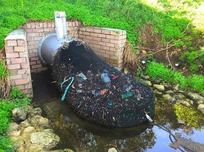
How Australia prevents storm drain trash from reaching the rivers, lakes and ocean
|
|
|
|
Image source
|
|
|
|
|
|
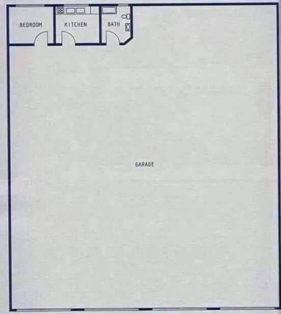
An engineer’s idea of a perfect house.
|
|
|
|
|
|
Image source
|
|
|
|
Enjoy,
James Lord (Star Lord James)
Solutions Consultant | U.S. CAD
Guardian of the Infrastructure Galaxy
|
|
|
|